Over Easter, we took a long weekend and flew down to Livingstone in southern Zambia to visit the Victoria Falls. At 1.5 km wide and 100 m high, the falls are an impressive site at any time of the year. At this time of the year, it is rainy season and the falls were in full flow. There is normally white water rafting in the canyons below the falls, but with such a high flow rate, they had cancelled that activity.
The falls are part in Zimbabwe and part in Zambia, but given the government forced decline in Zimbabwe, almost all tourists stay on the Zambian side nowadays. Zambia was a pleasant surprise, at least the small parts we saw of it. Good roads, almost every one speaks English, western clothes are common, and no power outages while we were there. Livingstone is quite the tourist area with many of the modern facilities run by South Africans. The town itself is somewhat dilapidated, but the road to the falls, 11 k away has many new hotels, shopping plazas, and restaurants catering to the more wealthy tourists. Livingston gets its name from Dr David Livingston the famous explorer back in the 1800s who bought news of Africa and its highlights to the then western world.
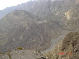
There are many activities set up for tourists to do and most hotels have an activities office which organise the bookings. The operators then come and pick you up from the hotel and drop you off afterwards if desired. The centre piece is of course the falls and all the different ways to see it. You can see the falls from pleasure boats from above the falls, you can fly over them in a helicopter or a microlight, walk down to the water’s edge where the water goes over the precipice. The best viewing is from the small park on the down stream side of the falls. The falls are part of the Zambezi river . The river is normally wide and gracefully flowing along. At the point of the falls however is a large deep fault that the water drops down into. From there the fault zigzags back and forth for many km downstream. All of the viewing anywhere is done from the top of the canyon, level with the top of the falls. Hence the downstream view of the falls is level with the top of the falls looking as the water falls down into the canyon. The flow rate is so high though (5 million lpm) that the thunder from the water is quite loud. There is a huge wall of mist rising out of the canyon that can be seen 30 km away. The local name for the falls translated means – the smoke that thunders. The mist rises up about 100 m above the falls then falls back to ground as rain. And rain it is! The little plateau, immediately downstream of the falls, is about 50 m from the water wall and where most of the viewing and pictures of the falls are taken. The falling mist just pelts down like a massive rain storm. No matter what you wear, you are going to get wet. Cameras and phones are going to get destroyed. Most tourists just walk in shorts and no shirt or a skimpy top, knowing they are going to get wet. One enterprising entrepreneur rents out rain jackets, but it is an exercise in futility as you are just going to get drenched. It is all quite fun to experience it. Then stand back 150 m from the falls and it is hot and dry.
On Friday night we took a river boat ride up above the falls on the African Princess, a sister boat to the African Queen. A little more luxurious than the boat used by Audrey Hepburn and Humphrey Bogart! The Zambian side of the river is another park that stretches up river a ways. People can ride elephants in the park. That didn’t appeal to us however too much.
On Saturday morning we took a helicopter ride (Flight of the Angels) over and around the falls which was a great way to see the whole geology of the area and understand why they are like they are. You can see the big hotels that Zimbabwe used to offer but now are hardly used. After that we got taken to the falls park and a guide spent a couple of hours with us showing us along the paths and telling us about the falls and their history. Yep, he too got soaked to the bone. For lunch we went to the Royal Livingstone Hotel. It is on the Zambezi River waterfront right just back from the top of the falls. A magnificent view and beautiful grounds plus a deck over the water for drinking cocktails and watching the sunset on the other side of the Zambezi, with the roar of the falls a 100m away. The wait staff are immaculately dressed, the maitre-d wearing a tux and tails. The reception staff wear the old English pith exploring helmets. Very quaint. The meals are superb and the desserts are a work of art. There are a number of shops around this hotel and another nearby that sell high end souvenirs and house decorations with an African flavour. After lunch we went back to the park at the falls for some more watching. There is a bridge over the canyon just down from the falls. The east end is Zimbabwe and the west is Zambia. We walked out on the bridge to watch the bungee jumping and gorge swings off it into the canyon.
On Sunday we went with an operator, Abseil Zambia, to one of the canyons about 3 km downstream. They had set up a series of adrenaline activities like flying foxes, gorge swings, abseiling down the cliffs there. We signed up for a couple of goes on each of the activities. The abseiling was the most moderate. It was Ramona’s first time to do this but she did well. It was 2 min to go down and then 30 mins to walk back out of the canyon. Next was the flying fox. They strapped you into a harness attached to the middle of your back. At the top the strap was attached to a pulley. The pulley then runs on a cable stretched across the canyon. When swinging you are suspended like you are flying through the air. This had a 5 m long run to the cliff edge and then you leapt off into space. While running the strap is not tight so when you get to the edge and jump off you fall for about ½ m and during that time your heart is in your mouth. Dang! Once the strap comes tight and you realise it is not going to break and plummet you to the rocks below, you find yourself hanging horizontally and flying along the cable out over the canyon. It is quite cool. On the last time I took the video camera with me to capture the flying over the precipice out into the canyon.
Next came the Gorge Swing. After having seen it earlier that morning I was quite dreading it. This is no ordinary swing! Like the flying fox it is based on a main wire stretched over the canyon. Another cable is attached at one end to a pulley rolling on the main wire. The other end of this swing cable is attached to you via a harness. The scary thing is that the swing cable does not get tight until you have fallen down into the canyon 53m. Only then does it come tight and act like a swing and you swing back and forth over the canyon. So you start off on standing on this concrete platform sticking out over the gorge. Then you jump off and literally free fall these 53m which takes about 3.5 seconds. Then the swing cable snaps tight and you swing out into the canyon. Wow, does that 3.5 secs scare the heck out of you. You see the cliff face just rushing past you so fast and your mind tells you it is all over. It was just scary how fast you are falling before the cable comes tight and takes the weight. Ramona and I did it twice as a tandem strapped to each other at the hip. Me being heavier would fall faster and Ramona would get pulled over on top of me just as the swing cable came tight. Then once the cable was tight it was a nice swing back and forth over the canyon for a few minutes till they lowered us down to the valley floor. One of the assistants took our video camera and videoed us during the event. Not a movie to be shown in public. That is some scary activity, boy!
Monday had us flying back to Lusaka, the Zambian capital where we had a few hours to wait until our flight back to TZ. The taxi driver we had met on Friday was there to pick us up and take us to a shopping mall. We caught a good ol USA movie full of car chases and shoot outs, “Armored.” The taxi driver then took us back to the airport for a midnight flight back to Nairobi then Arusha.
Friday, April 9, 2010
Wednesday, April 7, 2010
Another Water Well Drilling Project, Babati
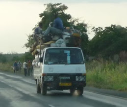
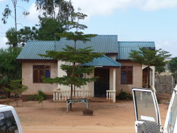
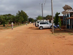
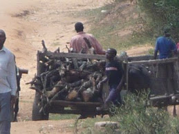
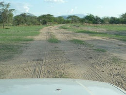
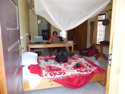
Another project is underway at an area called Babati. It started about 2 years ago and is a bit behind schedule and needs help. Babati is about a 4 hour drive west of Arusha. 2/3rds of the way is tarmac as that is the way to the game watching parks. After that, the last 60 km is on gravel road and that part takes a long time. Average speed of 25 km per hour on a lot of it. Thankfully there are some contractors from China who are in the process of getting the road ready to seal. It may be next year before it is done and should then be a boom to the Babati economy as it will then be a lot more accessible to Arusha and the tourist industry. Babati is close to the rift valley's huge escarpment so some of the scenery is quite picturesque. At the moment there is very little in the way of any facilities to attract tourists to the region. The roads are poor. It gets a lot of rain in the wet season and agriculture is full swing out there. Part of the project is to install a number of new water wells and rehabilitate older water points that no longer work. We have come out here to help with getting 20 new wells drilled. We spent part of January and February writing and sending out bid documents for water well location surveying and their drilling, then reviewing the offers. In mid March we drove out here in the Adra Land Cruiser and our little Pajero. The roads out here are way too rough for the Pajero and the Land Cruiser is the ideal vehicle to use for day to day work. Babati is a small town at a T intersection of 3 roads. The road to the east is to Arusha, to the west is the road to Dadoma and to the North is the road to Singida. The arms of the T are tarmac sealed for about 1 km in each of the three directions then it is rough gravel/dirt road. The town has the normal collection of guest houses, hardware stores, salons, a couple of banks, some bars, stationery stores and petrol stations. No western restaurants at all. We are staying at a small 9 room guest house called the White Rose and given where we are, it is quite nice. Some days it reminds us of Fawlty Towers with the one guy who runs everything, Michael, getting called in all different directions at once. The only other place to eat in town for Mzungus is Pik-n-Pay where a bowl of rice and beans is $2 and coke is 40 cents. You can only eat so many bowls of rice and beans over a couple of weeks, before your appetite starts to fade away.
The first weekend we got there, there was no work to do so we went for a hike up onto a hill behind the town. All dirt roads and crossing through peoples yards to get to the hill. It provided a nice overlook of the town and the lake on the nw end of the town.
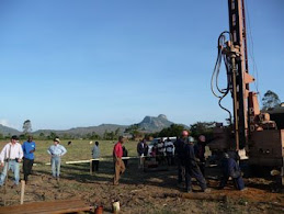
The drilling contractor Chuck we are using is from Oregon and has many years of drilling experience. He was with us in Gairo last year too. Chuck is an easy going retiree. Chuck already had his survey crew here by the time we arrived in Babati and the drilling crew arrived a couple of days later. The survey equipment was new to us. It measures electrical resistivity in the ground along a 600 m long line with electrodes spaced every 10 m apart. The signal can penetrate down to approx 100 m in depth. It shows the results on a coloured contour 2D plot. Low resistivity being clays, medium resistivity being sands and gravels (where the water would be located if it was there at all) and bed rock is high resistivity. It takes about a day to do one survey by the time we drive there on these roads, do the survey and get back, so it can be a slow process. Babati is a hilly region so it is unlikely that there will not be a place to drill somewhere along the 600 m line. However in many cases we struggle to find a place 600 m long to lay out the cables. The little valleys may not be that wide and at this time of year, any flat land is covered by 5 ft high maize plants. While the maize is ok to survey in, we cannot get the drill rig in there as the ground is too soft and the truck would get stuck. It is currently the rainy season where it rains on and off almost every day so any tilled ground is very soft. We could have waited till the end of the rainy season to drill but the project is rapidly running out of time as it is and delaying another couple of months would have been a bigger problem. The local government policy is to locate water wells 100 m away from any building or road, which is proving quite difficult to do in this terrain. We keep questioning what constitutes a road in this country? Is a dirt path in a maize field a road? No one can answer of course. To us putting a well somewhat close to a road makes more sense as it is then accessible to the well users, rather than make them carry their buckets across the country side. We had the same consensus in Gairo last year so not sure why it is different here. Also here there are more politics of a lot of other parties wanting to be involved and have their say which makes it slow to work out here.
Due to the number of officials watching us on site, we are being extra careful to document the progress and well performance. A hand pump can only pump about 500 liters per hour. We are endeavouring to drill to depths where we can get at least 2000 liters per hour. This may not be possible for all locations and so we spend quite a amount of time measuring the flow rate of water coming from the well over a few hours to verify it is suitable for a hand pump. To measure the flow rate, we use the rig compressor to air lift all the water from out of the hole. Once out of the hole the water falls on the ground and runs off to the low point. By making small earth works from the drill cuttings, we control where the water runs off to and can direct it to flow through a V-notch weir we made in town one day or if the ground is soft enough to dig a big enough hole in to hold a 20 l bucket down in it, then we flow the water through a 150 mm diameter PVC pipe and measure how long it takes to flow 20 liters of water into a 20 liter bucket held under the pipe outlet. From that we compute the flow per hour.
After 2 weeks we had only drilled 4 bores and had broken two down hole hammers and gotten stuck many times. Getting parts for the hammers proved tricky and they have to be ordered from India so this has bought the drilling to a halt for at least two weeks. That coupled with the problems the rain was causing of getting these heavy trucks stuck every time we got off a road means we are on hold for at least two weeks so we have come back to Arusha. The little town of Babati is on a slight downhill W-E slope. At the top of the town just north is a lake covering a couple of 100 acres. With all the rain, the level has risen to where the normal overflow outlet cannot handle the flow so the lake is spilling its water over the edge and into the main street of the town. On either side of the main street are 1 m deep and 1 m wide open drains to channel water off. The one on the lake side runs at full flow the whole time we have been there. The one on the other side of the street is blocked in a culvert and no one bothers to clean it out, so it is empty and can’t help with any run off. If more water flows from the lake than the first drain can handle, then the water flows across the main street in many places and at quite a few cm deep. It makes it hard for the locals who have to walk everywhere to walk around through this water and all the mud it creates along the side of the street and into any of the shops. About ½ of the area for the bus station is underwater that people have to walk through. The kids love these drains flowing with all the water. They take a mosquito net (probably from some well wishing donor) and since the nets are a nice conical shape it makes an ideal net to hold the opening across the width of the drain and catch fish in that have been caught up in the lake overflow. Some of them spend all day in the drain fishing, even on school days. Go figure!
The first weekend we got there, there was no work to do so we went for a hike up onto a hill behind the town. All dirt roads and crossing through peoples yards to get to the hill. It provided a nice overlook of the town and the lake on the nw end of the town.
The drilling contractor Chuck we are using is from Oregon and has many years of drilling experience. He was with us in Gairo last year too. Chuck is an easy going retiree. Chuck already had his survey crew here by the time we arrived in Babati and the drilling crew arrived a couple of days later. The survey equipment was new to us. It measures electrical resistivity in the ground along a 600 m long line with electrodes spaced every 10 m apart. The signal can penetrate down to approx 100 m in depth. It shows the results on a coloured contour 2D plot. Low resistivity being clays, medium resistivity being sands and gravels (where the water would be located if it was there at all) and bed rock is high resistivity. It takes about a day to do one survey by the time we drive there on these roads, do the survey and get back, so it can be a slow process. Babati is a hilly region so it is unlikely that there will not be a place to drill somewhere along the 600 m line. However in many cases we struggle to find a place 600 m long to lay out the cables. The little valleys may not be that wide and at this time of year, any flat land is covered by 5 ft high maize plants. While the maize is ok to survey in, we cannot get the drill rig in there as the ground is too soft and the truck would get stuck. It is currently the rainy season where it rains on and off almost every day so any tilled ground is very soft. We could have waited till the end of the rainy season to drill but the project is rapidly running out of time as it is and delaying another couple of months would have been a bigger problem. The local government policy is to locate water wells 100 m away from any building or road, which is proving quite difficult to do in this terrain. We keep questioning what constitutes a road in this country? Is a dirt path in a maize field a road? No one can answer of course. To us putting a well somewhat close to a road makes more sense as it is then accessible to the well users, rather than make them carry their buckets across the country side. We had the same consensus in Gairo last year so not sure why it is different here. Also here there are more politics of a lot of other parties wanting to be involved and have their say which makes it slow to work out here.
Due to the number of officials watching us on site, we are being extra careful to document the progress and well performance. A hand pump can only pump about 500 liters per hour. We are endeavouring to drill to depths where we can get at least 2000 liters per hour. This may not be possible for all locations and so we spend quite a amount of time measuring the flow rate of water coming from the well over a few hours to verify it is suitable for a hand pump. To measure the flow rate, we use the rig compressor to air lift all the water from out of the hole. Once out of the hole the water falls on the ground and runs off to the low point. By making small earth works from the drill cuttings, we control where the water runs off to and can direct it to flow through a V-notch weir we made in town one day or if the ground is soft enough to dig a big enough hole in to hold a 20 l bucket down in it, then we flow the water through a 150 mm diameter PVC pipe and measure how long it takes to flow 20 liters of water into a 20 liter bucket held under the pipe outlet. From that we compute the flow per hour.
After 2 weeks we had only drilled 4 bores and had broken two down hole hammers and gotten stuck many times. Getting parts for the hammers proved tricky and they have to be ordered from India so this has bought the drilling to a halt for at least two weeks. That coupled with the problems the rain was causing of getting these heavy trucks stuck every time we got off a road means we are on hold for at least two weeks so we have come back to Arusha. The little town of Babati is on a slight downhill W-E slope. At the top of the town just north is a lake covering a couple of 100 acres. With all the rain, the level has risen to where the normal overflow outlet cannot handle the flow so the lake is spilling its water over the edge and into the main street of the town. On either side of the main street are 1 m deep and 1 m wide open drains to channel water off. The one on the lake side runs at full flow the whole time we have been there. The one on the other side of the street is blocked in a culvert and no one bothers to clean it out, so it is empty and can’t help with any run off. If more water flows from the lake than the first drain can handle, then the water flows across the main street in many places and at quite a few cm deep. It makes it hard for the locals who have to walk everywhere to walk around through this water and all the mud it creates along the side of the street and into any of the shops. About ½ of the area for the bus station is underwater that people have to walk through. The kids love these drains flowing with all the water. They take a mosquito net (probably from some well wishing donor) and since the nets are a nice conical shape it makes an ideal net to hold the opening across the width of the drain and catch fish in that have been caught up in the lake overflow. Some of them spend all day in the drain fishing, even on school days. Go figure!
Loss of a Sister, Elinor
During February we made an unscheduled return trip to Louisiana to visit with Ramona’s terminally ill sister Elinor as her condition was deteriorating. We spent two weeks there visiting with her and helping their mother out with caring for Elinor. Sadly just after we returned to Tanzania, Elinor passed away, we are comforted to know she is no longer in pain. This was very hard on us even though all the family knew it was coming. Not being able to go to the funeral was disappointing for us; however, we shared in Elinor’s memorial service from here. Another memorial service for Elinor will also be held in Austin Texas, where the three of us lived for many years, and made many friends. It will be held in September this year, and we will be attending. Elinor will always be greatly missed by Ross, Ramona and her family. She’ll continue to live in our hearts.
Subscribe to:
Posts (Atom)


.JPG)


.JPG)


.JPG)